Preflight Works アプリを開くOpen the app

飛ばす前に、飛ばしてみる。

Fly it before you fly it.

ドローンの自動飛行経路を、仮想空間で検証するツールです。 地形・電波・樹木・建物を公的データで再現し、現地で何度も飛ばす前に、 経路と見え方を確かめられます。

A tool for testing automated drone flight paths in a virtual environment. Terrain, radio coverage, trees and buildings are reproduced from public data, so you can check the route and the view before flying it repeatedly on site.

現地での試行錯誤を、机の上へ

From the field to the desk

自動飛行の経路は、これまで現地で何度も飛ばし、試行錯誤を重ねて決めてきました。天候に左右され、人も時間もかかります。このツールは、その検討を机の上に移します。地形に沿った高度、電波の届く範囲、カメラに何が写るか。現地へ行く前に分かることは、現地へ行く前に確かめる。

Automated flight paths have always been worked out on site, flying again and again until they are right. That depends on the weather, and it costs people and time. This tool moves that work to the desk. The altitude that follows the terrain, how far the radio reaches, what the camera will actually see. Whatever can be settled before you go, settle before you go.

できること

What it does

地形に沿った経路を自動で引く

Draw a terrain-following route automatically

地図上に経路を描くと、地形追従とクルーズの2方式で高度を自動計算します。 DJI 機体がそのまま読み込める KMZ ファイルを書き出せます。

Draw a route on the map and the altitude is computed for you, either following the terrain or at a cruising height. Export a KMZ file that DJI aircraft read directly.
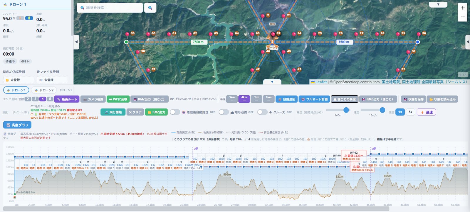
地図上で飛行経路を作っている画面
画面例(shots/route.jpg)

3Dで飛ばしてみる

Fly it in 3D

離陸から着陸まで、計画どおりに機体を飛ばして再生できます。 機体カメラの映像を出せば、その瞬間に何が写るかが分かります。 カメラの向きと画角を変えると、見え方がその場で変わります。

Replay the flight from take-off to landing exactly as planned. Turn on the aircraft camera and you see what is in frame at any moment. Change the camera angle or the field of view and the view updates as you watch.
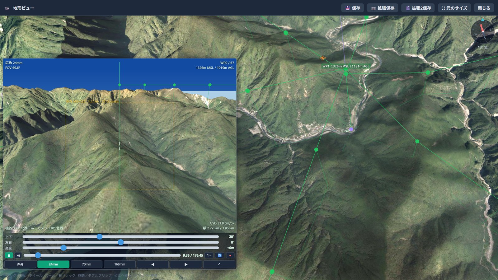
3Dの地形ビューで飛行を再生している画面
画面例(shots/view3d.jpg)

電波が届くか調べる

Check radio coverage

経路が通信状態で色分けされます。届かない区間は、迂回路を探します。

The route is colour-coded by link quality. Where the signal does not reach, the tool looks for a way around.
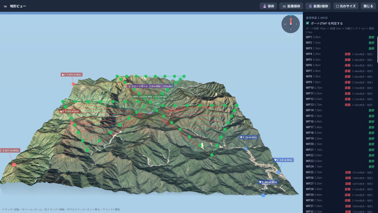
経路が通信状態で色分けされた画面
画面例(shots/radio.jpg)

防災情報を重ねる

Overlay disaster-risk data

土砂災害警戒区域、洪水・津波・高潮の浸水想定、地すべり地形、活断層、プレート境界。 防災目的でドローンを導入する際の検討材料になります。

Landslide warning zones, projected inundation from floods, tsunami and storm surge, landslide topography, active faults and plate boundaries. Useful when assessing drones for disaster response.
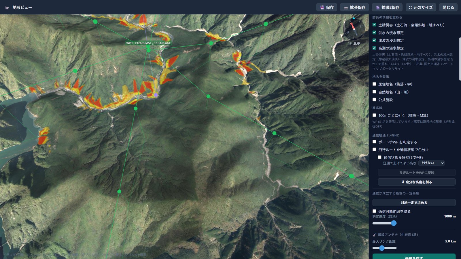
防災情報を地図に重ねた画面
画面例(shots/hazard.jpg)

使う流れ

How you use it

最初の1回は10分ほどで、離陸までたどり着けます。

The first time through, it takes about ten minutes to reach take-off.

1

ポートの位置を決める

Place the port

地図上でドローンポートの場所と設置高さを設定します。

Set the location and installation height of the drone port on the map.

2

地図に経路を描く

Draw the route

経由地を置くと、地形に沿った高度が自動で決まります。

Drop waypoints and the terrain-following altitude is set for you.

3

KMZ を書き出す

Export the KMZ

機体に読み込ませるファイルが出来上がります。

You get the file to load into the aircraft.

何に基づいているか

What it is based on

すべて公開されているデータです。どこから取った値かを、マニュアルに一覧で示しています。

All of it is public data. The manual lists where every value comes from.

地図・地形・標高国土地理院
Maps, terrain, elevationGeospatial Information Authority of Japan
飛行禁止区域・空域国土地理院
No-fly zones, airspaceGeospatial Information Authority of Japan
防災情報国土交通省ハザードマップポータル/防災科学技術研究所
Disaster-risk dataMLIT Hazard Map Portal / NIED
建物国土交通省 PLATEAU
BuildingsMLIT PLATEAU
施設OpenStreetMap contributors(ODbL)
FacilitiesOpenStreetMap contributors (ODbL)
KMZ の仕様DJI Cloud API ドキュメント
KMZ specificationDJI Cloud API documentation

ご利用の前提

Before you use it

本システムが表示する情報と書き出すファイルは参考情報であり、飛行の可否や安全を保証するものではありません。 飛行にあたっては航空法その他の関係法令を遵守し、必要な許可・承認を取得してください。
The information shown and the files produced by this system are for reference. They do not guarantee that a flight may be conducted, or that it will be safe. Comply with the Civil Aeronautics Act and other applicable law, and obtain any permissions and approvals that are required.

ご利用には購読が必要です。料金と契約の条件は、アプリ内でご確認いただけます。

A subscription is required. Pricing and the terms of the contract are shown inside the app.

世界の空を、デモで飛ぶ

Fly the world in demo mode

画面上部の「デモ」ボタンから、世界の火山、ダム、世界遺産を選んで、その上空を飛ばせます。実際の標高データで地形を再現しているので、行ったことのない場所でも、空から何がどう見えるかが分かります。飛ばした様子は、そのまま動画ファイルとして書き出せます。ログインしたら、まずはここから試してみてください。

The Demo button at the top of the app takes you to volcanoes, dams and World Heritage sites around the world, and flies you over them. The terrain is built from real elevation data, so you can see how a place you have never been to looks from the air. The flight itself can be exported as a video file. Once you are signed in, start here.

富士山(デモ)。左が機体カメラの映像、右が3Dの地形ビュー。25秒に編集しています。

Mount Fuji, in demo mode. The aircraft camera on the left, the 3D terrain view on the right. Edited down to 25 seconds.